


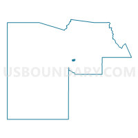
BETHUNE Voting District, Maricopa County, Arizona
About
Outline

Summary
| Unique Area Identifier | 524502 |
| Name | BETHUNE Voting District |
| County | Maricopa County |
| State | Arizona |
| Area (square miles) | 4.30 |
| Land Area (square miles) | 4.20 |
| Water Area (square miles) | 0.10 |
| % of Land Area | 97.66 |
| % of Water Area | 2.34 |
| Latitude of the Internal Point | 33.41883420 |
| Longtitude of the Internal Point | -112.10569230 |
Maps


Graphs
Select a template below for downloading or customizing gragh for BETHUNE Voting District, Maricopa County, Arizona


Neighbors
Neighoring Voting District (by Name) Neighboring Voting District on the Map
- BROADWAY Voting District, Maricopa County, AZ
- DUNBAR Voting District, Maricopa County, AZ
- HARRISON Voting District, Maricopa County, AZ
- HIDALGO Voting District, Maricopa County, AZ
- JACKSON Voting District, Maricopa County, AZ
- LOWELL Voting District, Maricopa County, AZ
- RIVERSIDE Voting District, Maricopa County, AZ
- ROESER Voting District, Maricopa County, AZ
- SOUTHERN Voting District, Maricopa County, AZ
- SULLIVAN Voting District, Maricopa County, AZ
- SUNLAND Voting District, Maricopa County, AZ
Top 10 Neighboring County Subdivision (by Population) Neighboring County Subdivision on the Map
Top 10 Neighboring Place (by Population) Neighboring Place on the Map
Top 10 Neighboring Elementary School District (by Population) Neighboring Elementary School District on the Map
- Roosevelt Elementary District, AZ (101,878)
- Phoenix Elementary District, AZ (55,104)
- Murphy Elementary District, AZ (17,265)
Top 10 Neighboring Secondary School District (by Population) Neighboring Secondary School District on the Map
Top 10 Neighboring State Legislative District Lower Chamber (by Population) Neighboring State Legislative District Lower Chamber on the Map
Top 10 Neighboring State Legislative District Upper Chamber (by Population) Neighboring State Legislative District Upper Chamber on the Map
Top 10 Neighboring 111th Congressional District (by Population) Neighboring 111th Congressional District on the Map
Top 10 Neighboring Census Tract (by Population) Neighboring Census Tract on the Map
- Census Tract 1147.03, Maricopa County, AZ (8,071)
- Census Tract 1125.14, Maricopa County, AZ (3,633)
- Census Tract 1148, Maricopa County, AZ (3,285)
- Census Tract 1149, Maricopa County, AZ (2,663)
- Census Tract 1143.02, Maricopa County, AZ (2,477)
- Census Tract 1154, Maricopa County, AZ (2,232)
- Census Tract 1144.02, Maricopa County, AZ (2,014)
- Census Tract 1144.01, Maricopa County, AZ (1,724)
- Census Tract 1173, Maricopa County, AZ (1,677)
- Census Tract 1142, Maricopa County, AZ (1,539)